China opens Tibet high-altitude drone test base to shape next-gen drone designs
{loadposition bannertop}
{loadposition sidebarpub}
China on Sept. 28 opened a high-altitude unmanned equipment testing base in Ngari (Ali), Tibet, at elevations above 4,500 meters, according to Xinhua. The site lets Chinese developers trial UAVs in thin air and cold turbulence, conditions tied to heavier payloads and longer endurance at elevation.
On September 28, 2025, China unveiled a new high-altitude unmanned equipment testing base in Ngari, Tibet, at more than 4,500 meters above sea level, as reported by Chinese Xinhua News Agency. Beyond a local infrastructure milestone, the site consolidates in one location the extreme conditions, thin air, low pressure, cold, and turbulent airflow, that shape the next wave of Chinese drone design. The announcement matters because platforms matured here can lift heavier payloads, cruise longer at elevation, and operate where conventional small and medium UAVs struggle. It also indicates a tighter alignment between civil “low-altitude economy” narratives and dual-use testing that supports rapid fielding. Multiple social media posts circulating alongside the opening referenced a new high-altitude drone dubbed “Ali Yundun-1,” but there is no official Chinese confirmation of that air vehicle or its specifications at this time.
Follow Army Recognition on Google News at this link
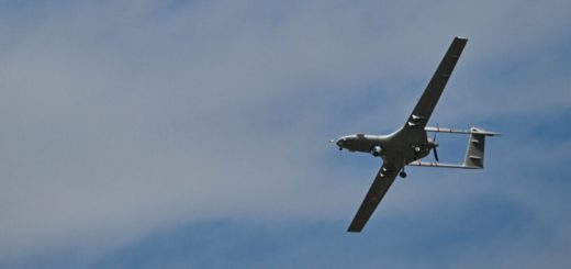
The opening of the Ngari high-altitude testing base signals a step change in how and where Chinese drones will be matured. By converting the Tibetan Plateau into an everyday proving ground, developers can normalize extreme-altitude flight regimes, de-risk key subsystems, and spin out designs that carry heavier sensors farther, for longer, in air that punishes conventional UAVs (Picture source: X account/Dana916)
The Ngari base gives engineers a repeatable, instrumented environment to resolve high-altitude bottlenecks that are notoriously expensive to tackle through simulation alone. Propulsion must be tuned for rarefied air to maintain lift and climb performance; electrical and fuel systems require cold-soak resilience; airframes need structural margins against gust loading and mountain wave phenomena; and flight control laws must cope with lower dynamic pressure. Concentrating these variables in a single plateau test hub shortens design cycles and reduces technical risk for families of drones intended to operate above 4,500 meters with meaningful payloads. Chinese officials frame the facility within a “low-altitude economy” that encompasses tourism imaging, emergency response, logistics, and infrastructure inspection. Yet the same adaptations, anti-icing, power-to-weight optimization, and robust communications at long line-of-sight ranges, translate directly into missions of persistent surveillance, relay, and mapping over rugged borders and sparsely populated interiors.
According to multiple social media accounts tied to the opening, a new drone referred to as “Ali Yundun-1” was presented with performance suited to plateau operations. Those claims, which describe a roughly 100-kg class air vehicle with multi-hour endurance and high wind tolerance, remain unverified by central-level Chinese sources. If broadly accurate, they reflect a design philosophy that privileges margin in propulsion and energy systems to offset altitude penalties while hardening against icing, a pattern consistent with the iterative way Chinese manufacturers have scaled civilian and paramilitary UAVs over the past decade. Historically, comparable challenges drove upgrades in other programs operating in mountainous theaters, where propulsion re-matches, de-icing kits, and airframe stiffening allowed surveillance drones to maintain station over valleys and high passes. The difference here is the institutionalization of those lessons at one of the world’s highest dedicated test sites, enabling faster transition from prototype to series production.
The facility’s location in western Tibet adds a layer of operational plausibility to what is nominally a test mission. Launching from a runway already above 4,500 meters reduces the energy required to reach cruising altitudes, extends time on station at elevation, and improves line-of-sight for sensors and communications payloads across ridgelines. That geometry provides inherent advantages for long-range mapping, wide-area surveillance, and network relay in terrain that degrades many commercial-derivative drones. It also allows developers to trial autonomy and swarming behaviors in air that is both less dense and more variable, stress-testing guidance and collision-avoidance algorithms under harder-to-simulate conditions. Such attributes will be closely watched by regional militaries and by global drone suppliers who compete in high-terrain markets from the Himalayas and Pamirs to the Andes and Rockies, where environmental fitness increasingly separates catalog specifications from real-world utility.
Economically, the Ngari site is designed to cut R&D costs by hosting shared certification and verification services while training a local technical workforce through university-lab-industry partnerships. That model accelerates commercialization of subsystems, engines, de-icing, flight controls, and power electronics, whose value chains are strategically important well beyond a single airframe. Geopolitically, the ability to standardize extreme-altitude testing strengthens export narratives for drones pitched to customers with mountainous borders, wildfire-prone hinterlands, or remote infrastructure. It also narrows the gap in a niche domain where high-altitude endurance and reliability have traditionally required bespoke, expensive solutions, potentially reshaping future procurement choices and interoperability assumptions in regions where elevation, cold, and wind define the operating envelope.
The opening of the Ngari high-altitude testing base signals a step change in how and where Chinese drones will be matured. By converting the Tibetan Plateau into an everyday proving ground, developers can normalize extreme-altitude flight regimes, de-risk key subsystems, and spin out designs that carry heavier sensors farther, for longer, in air that punishes conventional UAVs. The broader message is clear: expect more Chinese platforms optimized from the outset for high-elevation operations and more competition in missions where altitude and weather used to be the decisive constraints.
Written by Teoman S. Nicanci – Defense Analyst, Army Recognition Group
Teoman S. Nicanci holds degrees in Political Science, Comparative and International Politics, and International Relations and Diplomacy from leading Belgian universities, with research focused on Russian strategic behavior, defense technology, and modern warfare. He is a defense analyst at Army Recognition, specializing in the global defense industry, military armament, and emerging defense technologies.

{loadposition bannertop}
{loadposition sidebarpub}
China on Sept. 28 opened a high-altitude unmanned equipment testing base in Ngari (Ali), Tibet, at elevations above 4,500 meters, according to Xinhua. The site lets Chinese developers trial UAVs in thin air and cold turbulence, conditions tied to heavier payloads and longer endurance at elevation.
On September 28, 2025, China unveiled a new high-altitude unmanned equipment testing base in Ngari, Tibet, at more than 4,500 meters above sea level, as reported by Chinese Xinhua News Agency. Beyond a local infrastructure milestone, the site consolidates in one location the extreme conditions, thin air, low pressure, cold, and turbulent airflow, that shape the next wave of Chinese drone design. The announcement matters because platforms matured here can lift heavier payloads, cruise longer at elevation, and operate where conventional small and medium UAVs struggle. It also indicates a tighter alignment between civil “low-altitude economy” narratives and dual-use testing that supports rapid fielding. Multiple social media posts circulating alongside the opening referenced a new high-altitude drone dubbed “Ali Yundun-1,” but there is no official Chinese confirmation of that air vehicle or its specifications at this time.
The opening of the Ngari high-altitude testing base signals a step change in how and where Chinese drones will be matured. By converting the Tibetan Plateau into an everyday proving ground, developers can normalize extreme-altitude flight regimes, de-risk key subsystems, and spin out designs that carry heavier sensors farther, for longer, in air that punishes conventional UAVs (Picture source: X account/Dana916)
The Ngari base gives engineers a repeatable, instrumented environment to resolve high-altitude bottlenecks that are notoriously expensive to tackle through simulation alone. Propulsion must be tuned for rarefied air to maintain lift and climb performance; electrical and fuel systems require cold-soak resilience; airframes need structural margins against gust loading and mountain wave phenomena; and flight control laws must cope with lower dynamic pressure. Concentrating these variables in a single plateau test hub shortens design cycles and reduces technical risk for families of drones intended to operate above 4,500 meters with meaningful payloads. Chinese officials frame the facility within a “low-altitude economy” that encompasses tourism imaging, emergency response, logistics, and infrastructure inspection. Yet the same adaptations, anti-icing, power-to-weight optimization, and robust communications at long line-of-sight ranges, translate directly into missions of persistent surveillance, relay, and mapping over rugged borders and sparsely populated interiors.
According to multiple social media accounts tied to the opening, a new drone referred to as “Ali Yundun-1” was presented with performance suited to plateau operations. Those claims, which describe a roughly 100-kg class air vehicle with multi-hour endurance and high wind tolerance, remain unverified by central-level Chinese sources. If broadly accurate, they reflect a design philosophy that privileges margin in propulsion and energy systems to offset altitude penalties while hardening against icing, a pattern consistent with the iterative way Chinese manufacturers have scaled civilian and paramilitary UAVs over the past decade. Historically, comparable challenges drove upgrades in other programs operating in mountainous theaters, where propulsion re-matches, de-icing kits, and airframe stiffening allowed surveillance drones to maintain station over valleys and high passes. The difference here is the institutionalization of those lessons at one of the world’s highest dedicated test sites, enabling faster transition from prototype to series production.
The facility’s location in western Tibet adds a layer of operational plausibility to what is nominally a test mission. Launching from a runway already above 4,500 meters reduces the energy required to reach cruising altitudes, extends time on station at elevation, and improves line-of-sight for sensors and communications payloads across ridgelines. That geometry provides inherent advantages for long-range mapping, wide-area surveillance, and network relay in terrain that degrades many commercial-derivative drones. It also allows developers to trial autonomy and swarming behaviors in air that is both less dense and more variable, stress-testing guidance and collision-avoidance algorithms under harder-to-simulate conditions. Such attributes will be closely watched by regional militaries and by global drone suppliers who compete in high-terrain markets from the Himalayas and Pamirs to the Andes and Rockies, where environmental fitness increasingly separates catalog specifications from real-world utility.
Economically, the Ngari site is designed to cut R&D costs by hosting shared certification and verification services while training a local technical workforce through university-lab-industry partnerships. That model accelerates commercialization of subsystems, engines, de-icing, flight controls, and power electronics, whose value chains are strategically important well beyond a single airframe. Geopolitically, the ability to standardize extreme-altitude testing strengthens export narratives for drones pitched to customers with mountainous borders, wildfire-prone hinterlands, or remote infrastructure. It also narrows the gap in a niche domain where high-altitude endurance and reliability have traditionally required bespoke, expensive solutions, potentially reshaping future procurement choices and interoperability assumptions in regions where elevation, cold, and wind define the operating envelope.
The opening of the Ngari high-altitude testing base signals a step change in how and where Chinese drones will be matured. By converting the Tibetan Plateau into an everyday proving ground, developers can normalize extreme-altitude flight regimes, de-risk key subsystems, and spin out designs that carry heavier sensors farther, for longer, in air that punishes conventional UAVs. The broader message is clear: expect more Chinese platforms optimized from the outset for high-elevation operations and more competition in missions where altitude and weather used to be the decisive constraints.
Written by Teoman S. Nicanci – Defense Analyst, Army Recognition Group
Teoman S. Nicanci holds degrees in Political Science, Comparative and International Politics, and International Relations and Diplomacy from leading Belgian universities, with research focused on Russian strategic behavior, defense technology, and modern warfare. He is a defense analyst at Army Recognition, specializing in the global defense industry, military armament, and emerging defense technologies.